
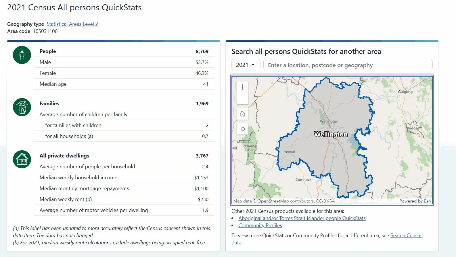
Wellington Statistical Area Population.
DEEPLY FLAWED misleading figures representing
Wellington’s population by 1000 people, discovered in a recent Dubbo Regional Council draft report questions whether the town and district have been short-changed over the past five years.
Australian Bureau of Statistics (ABS) from the 2021 census have been used in the “Dubbo and Wellington Pedestrian Access and Mobility Plan and Bike Plan” (PAMP), and are detailed on page 29.
While the mayor on Wellington’s Binjang community radio said the population figures had been rectified, the question of just what damage have they caused this past five years must be asked.
Binjang radio manager Tony Graham said the table on page 29 of the report showed the population at 4101 claimed to be sourced from the ABS 2021 census.
“This is a figure reflecting a tight boundary around Wellington suburbia that the ABS has listed on its website as 4096, leaving out Montefiores (630) and low-density blocks on the Wellington periphery, including Apsley (116) with Nanima Village down to the Wellington Caves, Mt Arthur including the Gould League Estate and the Cadonia Estate (33),” he said.
“That brings the Wellington population to almost 5000 at 4984.
“Council has since revised the figure upwards in the report to less, at 4835. These statistics do not include the gaol population or the large contingent of itinerant workers living in the area.”
Mr Graham said that on the other hand, the 2021 ABS statistics for Dubbo included boundaries with a large peripheral area down to the zoo, east to Firgrove Estate and south east to Bencubbin Road state a population of 40,578, somewhat less than what is tabled in the PAMP report at 43,535.
“Unbelievingly, this is the second time Council has been caught out using these same flawed statistics in their committee submissions and the potential consequences are quite serious as per-capita metrics come into play,” he said.
“Importantly, these statistics are applied to management decisions and the disbursement of revenue.
“They are central to the level of service provision, deployment of infrastructure and infrastructure maintenance decisions, and directly affecting, to various degrees, the level of expenditure in council budgets and the application of grants from its main funding body, the NSW State Government.
“It raises the question as to the number of affected planning documents and budgets and to what extent they’ve been skewed by inaccurate figures, plus how long this has been going on for.”
The PAMP population statistics in the population table relating to the previous 2016 ABS census indicate this has been going on even from that time.
“A third document, the “Dubbo Region Key Economic Indicators - June 2024” located on council’s website, propagates the same incorrect population statistics that have been turning up in council’s planning documents,” Mr Graham said.
“This is a central document that appears when searching about the Dubbo Region.
“It appears the Key Economic Indicators metrics are also misleading in the isolated data section as they fail to differentiate between the urban centralised economy of Dubbo and the decentralised economy of Wellington,
statistically different because the Wellington economy is not mainly confined to urban Wellington whereas Dubbo is.
“Wellington should be represented with all of its decentralised economic zone that includes agricultural production, corrective services and the huge investment in the renewable energy zone.
“Back then the ABS defined Wellington as “The Wellington Statistical Area”, with a population of 8769, an area equivalent to the old Wellington Local Government Area.”
Mr Graham said business investors approaching Council about opportunities in the Regional Area relying on the Key Economic Indicators for the Wellington area would be misinformed by it.
“Wellington would be better represented as ‘The Wellington Statistical Area’,” he said.
“These failures raise questions about the lack of a local DRC management presence in the Greater Wellington Area and the knowledge vacuum that goes with it.
“It also points to an imperative to reorganise its management structure to reflect the changes brought about by the amalgamation of Dubbo City Council and Wellington Shire Council.
“The ‘Dubbo Region Key Economic Indicators’ can only be seen as a complete failure for the economy of Greater Wellington.
“The people need answers,” Mr Graham said.
Contents in this article and supporting ABS statistical documents have been presented to all councilors of the Dubbo Regional Council prior to the Ordinary Council Meeting of Dubbo Regional Council held on Tuesday, February 22.
Response by Dubbo Regional Council
Dubbo Regional Council uses data available through the Australian Bureau of Statistics (ABS) and REMPLAN.
In this instance, data was used from the ABS Suburbs and localities data, which only includes the Wellington township and does not include the surrounding areas.
This has now been corrected to include localities around Wellington as well in the statistical data referenced.